|
|
Antenna Structure Registration 1021320 |
 |
Registration Info | Registration Number: 1021320 |
| File Number: A0922882 |
| FAA Study: 97-ASW-1636-OE |
| FAA Issue Date: 07/18/1997 |
| Status: Constructed |
| Date Constructed: 01/01/1984 |
| FAA EMI: N |
| NEPA: N |
Structure Info
| Structure Type: TOWER |
| Structure Coordinates: 31-17-30.0 N 92-28-25.0 W (NAD 83) |
| Structure Coordinates: 31-17-29.3 N 92-28-24.5 W (Converted to NAD 27) |
| Structure Address: 1115 Texas Ave |
| Structure City: Alexandria, LA |
| Structure County: Rapides Parish |
| Painting & Lighting Info |
FCC Paragraph(s): 1, 3, 11, 21 |
| Elevation Info |
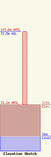
Site Elevation: 31.1 meters (102 ft) |
| Height of Structure: 72.5 meters (238 feet) |
| Overall Height Above Ground: 72.5 meters (238 feet) |
| Overall Height Above Mean Sea Level: 103.6 meters (340 feet) |
| Owner Info | Cenla Broadcasting Company, Inc. (KQID)
1115 Texas Ave
Alexandria, LA 71201
(318) 445-1234
taylor@cenlabroadcasting.com |
| Contact Info | Hardy, Carey, Chautin & Balkin, LLP
1080 West Causeway Approach
Mandeville, LA 70471
(985) 629-0777
jchautin@hardycarey.com |
