|
|
Antenna Structure Registration 1022260 |
 |
Registration Info | Registration Number: 1022260 |
| File Number: A1152114 |
| FAA Study: 94-ANM-0112-OE |
| Status: Constructed |
| Date Constructed: 09/01/1994 |
| FAA EMI: N |
| NEPA: N |
Structure Info
| Structure Type: TOWER |
| Structure Coordinates: 40-38-32.0 N 104-49-7.0 W (NAD 83) |
| Structure Coordinates: 40-38-32.1 N 104-49-05.1 W (Converted to NAD 27) |
| Structure Address: 12751 Weld County Rd 90 |
| Structure City: Pierce, CO |
| Structure County: Weld County |
| Painting & Lighting Info |
FAA Circular #: 70/7460-1H |
FAA Chapters: 3, 4, 5, 13 |
| Elevation Info |
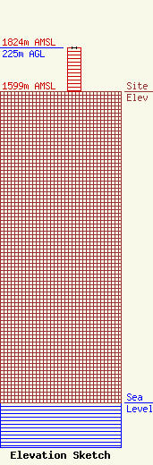
Site Elevation: 1599 meters (5246 ft) |
| Height of Structure: 224 meters (735 feet) |
| Overall Height Above Ground: 225 meters (738 feet) |
| Overall Height Above Mean Sea Level: 1824 meters (5984 feet) |
| Owner Info | Tribune Broadcasting Company II LLC
303 E. Wacker Drive
Chicago, IL 60601
(312) 222-3894
jasroberts@nexstar.tv |
| Contact Info | Tribune Broadcasting Company II LLC
303 E. Wacker Drive
Chicago, IL 60601
Jason Roberts
(312) 222-3894
jasroberts@nexstar.tv |
