|
|
Antenna Structure Registration 1022308 |
 |
Registration Info | Registration Number: 1022308 |
| File Number: A0026644 |
| Status: Constructed |
| Date Constructed: 02/01/1995 |
| NEPA: N |
Structure Info
| Structure Type: TOWER |
| Structure Coordinates: 31-22-22.0 N 92-38-10.0 W (NAD 83) |
| Structure Coordinates: 31-22-21.4 N 92-38-09.5 W (Converted to NAD 27) |
| Structure Address: 2 Mi Hwy 1 N |
| Structure City: Boyce, LA |
| Structure County: Rapides Parish |
| Painting & Lighting Info |
FCC Paragraph(s): 1, 3, 12, 21 |
| Elevation Info |
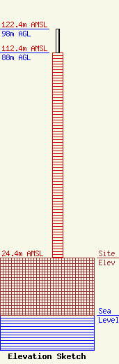
Site Elevation: 24.4 meters (80 ft) |
| Height of Structure: 88 meters (289 feet) |
| Overall Height Above Ground: 98 meters (322 feet) |
| Overall Height Above Mean Sea Level: 122.4 meters (402 feet) |
| Owner Info | TRINITY BROADCASTING CORPORATION DBA = KBCE FM
7771 HWY 1 N
69
BOYCE, LA 71409
(318) 793-4003
|
