|
|
Antenna Structure Registration 1022482 |
 |
Registration Info | Registration Number: 1022482 |
| File Number: A0978693 |
| FAA Study: 89-ANE-303-OE |
| FAA Issue Date: 01/25/1990 |
| Status: Constructed |
| Date Constructed: 10/01/1993 |
| NEPA: N |
Structure Info
| Structure Type: TOWER |
| Structure Coordinates: 43-54-12.0 N 70-2-11.0 W (NAD 83) |
| Structure Coordinates: 43-54-11.7 N 70-02-12.8 W (Converted to NAD 27) |
| Structure Address: Oak Hill .64 Km E Of Highland Rd |
| Structure City: Brunswick, ME |
| Structure County: Cumberland County |
| Painting & Lighting Info |
FAA Circular #: 70/7460-1G |
FAA Chapters: 3, 4, 5, 9 |
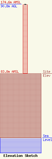
| Elevation Info |
Site Elevation: 83.8 meters (275 ft) |
| Height of Structure: 90 meters (295 feet) |
| Overall Height Above Ground: 90.8 meters (298 feet) |
| Overall Height Above Mean Sea Level: 174.6 meters (573 feet) |
| Owner Info | Atlantic Coast Radio, LLC
779 Warren Avenue
Portland, ME 04103
(207) 773-9695
lamenconi@gmail.com |
| Contact Info | GARVEY SCHUBERT BARER
1000 POTOMAC STREET, N.W.
Washington, DC 20007
Melodie Virtue
(202) 965-7880
mvirtue@gsblaw.com |
