|
|
Antenna Structure Registration 1022667 |
 |
Registration Info | Registration Number: 1022667 |
| File Number: A1348054 |
| FAA Study: 2016-ANE-747-OE |
| FAA Issue Date: 05/16/2016 |
| Status: Constructed |
| Date Constructed: 06/28/2016 |
| NEPA: N |
Structure Info
| Structure Type: GTOWER |
| Structure Coordinates: 43-41-17.1 N 70-15-25.0 W (NAD 83) |
| Structure Coordinates: 43-41-16.8 N 70-15-26.8 W (Converted to NAD 27) |
| Structure Address: 189 Presumpscot St Rear |
| Structure City: Portland, ME |
| Structure County: Cumberland County |
| Painting & Lighting Info |
FAA Circular #: 70/7460-1L |
FAA Chapters: 4, 8, 12 |
Remarks: PRIOR STUDY 2004-ANE-699-OE |
| Elevation Info |
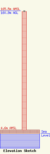
Site Elevation: 4.6 meters (15 ft) |
| Height of Structure: 160 meters (525 feet) |
| Overall Height Above Ground: 160.9 meters (528 feet) |
| Overall Height Above Mean Sea Level: 165.5 meters (543 feet) |
| Owner Info | GTC Uno, LLC
PO Box 2359
Ponte Vedra Beach, FL 32004
(844) 482-8977
regulatory@gtctowers.com |
| Contact Info | GTC Uno, LLC
PO Box 2359
Ponte Vedra Beach, FL 32004
(844) 482-8977
regulatory@gtctowers.com |
