|
|
Antenna Structure Registration 1022900 |
 |
Registration Info | Registration Number: 1022900 |
| File Number: A0788027 |
| FAA Study: 00-ANE-0479-OE |
| FAA Issue Date: 10/03/2000 |
| Status: Constructed |
| Date Constructed: 04/27/1987 |
| FAA EMI: N |
| NEPA: N |
Structure Info
| Structure Type: TOWER |
| Structure Coordinates: 43-25-11.0 N 70-48-9.0 W (NAD 83) |
| Structure Coordinates: 43-25-10.7 N 70-48-10.8 W (Converted to NAD 27) |
| Structure Address: Mount Hope Rd Cobbett Farm |
| Structure City: Sanford, ME |
| Structure County: York County |
| Painting & Lighting Info |
FAA Circular #: 70/7460-1K |
FAA Chapters: 3, 12 |
Remarks: PRIOR STUDY 69-BOS-217-OE |
Remarks: Removed expiration date from determination. Scenario 1./jjs/case#635066 |
Remarks: PRIOR STUDY 69-BOS-217-OE |
Remarks: Removed expiration date from determination. Scenario 1./jjs/case#635066 |
| Elevation Info |
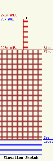
Site Elevation: 203 meters (666 ft) |
| Height of Structure: 69 meters (226 feet) |
| Overall Height Above Ground: 73 meters (240 feet) |
| Overall Height Above Mean Sea Level: 276 meters (906 feet) |
| Owner Info | Aruba Capital Holdings, LLC
1540
Exeter, NH 03833-1540
(603) 583-4767
sthomas@thomasmediagroup.com |
| Info |
