|
|
Antenna Structure Registration 1023324 |
 |
Registration Info | Registration Number: 1023324 |
| File Number: A1381208 |
| FAA Study: 2023-ANE-6017-OE |
| FAA Issue Date: 12/07/2023 |
| Status: Constructed |
| Date Constructed: 01/01/1965 |
| NEPA: N |
Structure Info
| Structure Type: GTOWER |
| Structure Coordinates: 41-35-49.0 N 71-11-22.0 W (NAD 83) |
| Structure Coordinates: 41-35-48.6 N 71-11-23.8 W (Converted to NAD 27) |
| Structure Address: Lafayette Rd |
| Structure City: Tiverton, RI |
| Structure County: Newport County |
| Painting & Lighting Info |
FAA Circular #: 70/7460-1M |
FAA Chapters: 4, 9, 15 |
| Elevation Info |
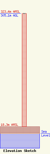
Site Elevation: 18.3 meters (60 ft) |
| Height of Structure: 305.1 meters (1001 feet) |
| Overall Height Above Ground: 305.1 meters (1001 feet) |
| Overall Height Above Mean Sea Level: 323.4 meters (1061 feet) |
| Owner Info | CTI Towers Assets, III, LLC c/o Symphony Towers Infrastructure
44 South Broadway
White Plains, NY 10601
(919) 655-7831
ccooper@symphonyinfra.com |
| Contact Info | CTI Towers Assets, III, LLC c/o Symphony Towers Infrastructure
44 South Broadway
White Plains, NY 10601
Christine Cooper
(919) 655-7831
ccooper@symphonyinfra.com |
