|
|
Antenna Structure Registration 1023891 |
 |
Registration Info | Registration Number: 1023891 |
| File Number: A1127933 |
| FAA Study: 2017-AGL-18562-OE |
| FAA Issue Date: 10/25/2017 |
| Status: Constructed |
| Date Constructed: 07/01/1990 |
| NEPA: N |
Structure Info
| Structure Type: GTOWER |
| Structure Coordinates: 44-15-53.7 N 94-25-50.5 W (NAD 83) |
| Structure Coordinates: 44-15-53.8 N 94-25-49.6 W (Converted to NAD 27) |
| Structure Address: Intersection Of Hwy 68 & 15 |
| Structure City: New Ulm, MN |
| Structure County: Brown County |
| Painting & Lighting Info |
FAA Circular #: 70/7460-1L |
FAA Chapters: 4, 8, 12 |
| Elevation Info |
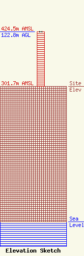
Site Elevation: 301.7 meters (990 ft) |
| Height of Structure: 121.9 meters (400 feet) |
| Overall Height Above Ground: 122.8 meters (403 feet) |
| Overall Height Above Mean Sea Level: 424.5 meters (1393 feet) |
| Owner Info | Alltel Corporation
5055 North Point Pkwy
Alpharetta, GA 30022
(770) 797-1070
Network.Regulatory@verizonwireless.com |
| Contact Info | Alltel Corporation
5055 North Point Pkwy
Alpharetta, GA 30022
Regulatory Manager
(770) 797-1070
Network.Regulatory@verizonwireless.com |
