|
|
Antenna Structure Registration 1024107 |
 |
Registration Info | Registration Number: 1024107 |
| File Number: A0028778 |
| FAA Study: 94-ANM-0745-OE |
| FAA Issue Date: 09/07/1994 |
| Status: Constructed |
| Date Constructed: 11/30/1992 |
| NEPA: N |
Structure Info
| Structure Type: TOWER |
| Structure Coordinates: 38-18-50.0 N 108-12-11.0 W (NAD 83) |
| Structure Coordinates: 38-18-50.0 N 108-12-08.7 W (Converted to NAD 27) |
| Structure Address: Raspberry Electronic Site Lot 8 |
| Structure City: Montrose, CO |
| Structure County: Montrose County |
| Painting & Lighting Info |
FAA Circular #: 70/7460-1H |
FAA Chapters: 3, 4, 5, 13 |
Remarks: RED LIGHTS/PAINT |
| Elevation Info |
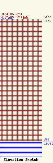
Site Elevation: 3035.8 meters (9960 ft) |
| Height of Structure: 69 meters (226 feet) |
| Overall Height Above Ground: 69 meters (226 feet) |
| Overall Height Above Mean Sea Level: 3104.8 meters (10186 feet) |
| Owner Info | MONTROSE, COUNTY OF DBA = REG 10 LEAGUE FOR ECON ASST & PLANNING
849
MONTROSE, CO 81402
(970) 249-7755
|
