|
|
Antenna Structure Registration 1024109 |
 |
Registration Info | Registration Number: 1024109 |
| File Number: A1381176 |
| FAA Study: 84-AGL-1112-OE |
| Status: Constructed |
| Date Constructed: 01/01/1984 |
| FAA EMI: N |
| NEPA: N |
Structure Info
|
| Structure Coordinates: 39-55-43.0 N 86-10-55.0 W (NAD 83) |
| Structure Coordinates: 39-55-42.9 N 86-10-55.0 W (Converted to NAD 27) |
| Structure Address: Ditch Rd At W 96th St |
| Structure City: Indianapolis, IN |
| Structure County: Hamilton County |
| Painting & Lighting Info |
FAA Circular #: 70/7460-1F |
FAA Chapters: 3, 4, 5, 9 |
| Elevation Info |
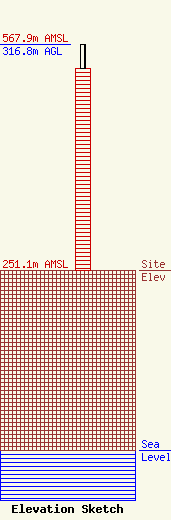
Site Elevation: 251.1 meters (824 ft) |
| Height of Structure: 283.3 meters (929 feet) |
| Overall Height Above Ground: 316.8 meters (1039 feet) |
| Overall Height Above Mean Sea Level: 567.9 meters (1863 feet) |
| Owner Info | VideoIndiana, Inc.
8401 Greensboro Drive
McLean, VA 22102
(703) 873-6600
lawdept@tegna.com |
| Contact Info | TEGNA Inc.
8401 Greensboro Drive
McLean, VA 22102
Denise Branson
(703) 873-6606
dbranson@tegna.com |
