|
|
Antenna Structure Registration 1024148 |
 |
Registration Info | Registration Number: 1024148 |
| File Number: A1326034 |
| FAA Study: 2018-AGL-20226-OE |
| FAA Issue Date: 10/08/2019 |
| Status: Constructed |
| Date Constructed: 11/26/2019 |
| NEPA: N |
Structure Info
| Structure Type: MTOWER |
| Structure Coordinates: 46-41-18.0 N 93-35-59.0 W (NAD 83) |
| Structure Coordinates: 46-41-18.2 N 93-35-58.1 W (Converted to NAD 27) |
| Structure Address: Nw 1/4 Se 1/4 Sec 35 T49 R26 4th Pm |
| Structure City: Aitkin County, MN |
| Structure County: Aitkin County |
| Painting & Lighting Info |
FAA Circular #: 70/7460-1L |
FAA Chapters: 3, 4, 5, 12 |
Remarks: PRIOR STUDY 1994-AGL-2877-OE |
Remarks: OM&L to remain the same as prior study = PAINT/RED LIGHTS |
Remarks: PRIOR STUDY 1994-AGL-2877-OE |
Remarks: OM&L to remain the same as prior study = PAINT/RED LIGHTS |
| Elevation Info |
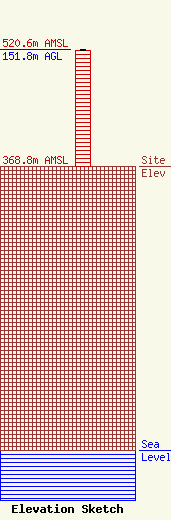
Site Elevation: 368.8 meters (1210 ft) |
| Height of Structure: 151 meters (495 feet) |
| Overall Height Above Ground: 151.8 meters (498 feet) |
| Overall Height Above Mean Sea Level: 520.6 meters (1708 feet) |
| Owner Info | R&J Broadcasting, Inc.
312 West Main Street
Ada, MN 56510
(218) 784-6319
jim@rjbroadcasting.com |
| Contact Info | R&J Broadcasting, Inc.
312 West Main Street
Ada, MN 56510
Jimmy Birkemeyer
(218) 784-6319
jim@rjbroadcasting.com |
