|
|
Antenna Structure Registration 1024373 |
 |
Registration Info | Registration Number: 1024373 |
| File Number: A1063965 |
| FAA Study: 97-ASO-1974-OE |
| FAA Issue Date: 05/30/1997 |
| Status: Constructed |
| Date Constructed: 04/07/1981 |
| FAA EMI: N |
| NEPA: N |
Structure Info
| Structure Type: TOWER |
| Structure Coordinates: 34-22-3.0 N 79-19-48.0 W (NAD 83) |
| Structure Coordinates: 34-22-02.4 N 79-19-48.8 W (Converted to NAD 27) |
| Structure Address: 2.7 Mi S Of Rt 9 And 1.2 Mi E Of Little Pee Dee River |
| Structure City: Floyd Dale, SC |
| Structure County: Dillon County |
| Painting & Lighting Info |
FAA Circular #: 70/7460-1J |
FAA Chapters: 4, 7, 13 |
Remarks: PREVIOUS STUDY 77-ASO-1609-OE. |
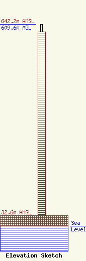
| Elevation Info |
Site Elevation: 32.6 meters (107 ft) |
| Height of Structure: 585.6 meters (1921 feet) |
| Overall Height Above Ground: 609.6 meters (2000 feet) |
| Overall Height Above Mean Sea Level: 642.2 meters (2107 feet) |
| Owner Info | WPDE Licensee, LLC
Pillsbury Winthrop Shaw Pittman LLP
Washington, DC 20036
(202) 663-8195
miles.mason@pillsburylaw.com |
| Contact Info | WPDE Licensee, LLC
Pillsbury Winthrop Shaw Pittman LLP
Washington, DC 20036
(202) 663-8195
miles.mason@pillsburylaw.com |
