|
|
Antenna Structure Registration 1024381 |
 |
Registration Info | Registration Number: 1024381 |
| File Number: A1218879 |
| FAA Study: 2018-AEA-7322-OE |
| FAA Issue Date: 06/25/2018 |
| Status: Constructed |
| Date Constructed: 10/08/2021 |
| NEPA: N |
Structure Info
| Structure Type: GTOWER |
| Structure Coordinates: 37-12-3.3 N 80-8-52.8 W (NAD 83) |
| Structure Coordinates: 37-12-02.8 N 80-08-53.7 W (Converted to NAD 27) |
| Structure Address: Atop Poor Mountain |
| Structure City: Roanoke, VA |
| Structure County: Roanoke County |
| Painting & Lighting Info |
FAA Circular #: 70/7460-1K |
FAA Chapters: 4, 6, 12 |
Remarks: PRIOR STUDY 2007-AEA-4519-OE |
Remarks: OM&L to remain the same as prior study = 24-HR MED-STROBES |
Remarks: PRIOR STUDY 2007-AEA-4519-OE |
Remarks: OM&L to remain the same as prior study = 24-HR MED-STROBES |
| Elevation Info |
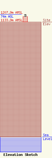
Site Elevation: 1133.9 meters (3720 ft) |
| Height of Structure: 52.1 meters (171 feet) |
| Overall Height Above Ground: 74 meters (243 feet) |
| Overall Height Above Mean Sea Level: 1207.9 meters (3963 feet) |
| Owner Info | Graham Media Group, Virginia, LLC
161 North Clark, Suite 2900
Chicago, IL 60601
(312) 917-6250
hwhiting@grahammedia.com |
| Contact Info | Graham Media Group, Virginia, LLC
821 5th Street NE
Roanoke, VA 24016
Ricky Williams
(540) 512-1542
rwilliams@wsls.com |
