|
|
Antenna Structure Registration 1024383 |
 |
Registration Info | Registration Number: 1024383 |
| File Number: A1063946 |
| FAA Study: 97-ANE-0102-OE |
| FAA Issue Date: 05/16/1997 |
| Status: Constructed |
| Date Constructed: 03/31/1975 |
| FAA EMI: N |
| NEPA: N |
Structure Info
| Structure Type: TOWER |
| Structure Coordinates: 43-55-29.0 N 70-29-27.0 W (NAD 83) |
| Structure Coordinates: 43-55-28.7 N 70-29-28.8 W (Converted to NAD 27) |
| Structure Address: Brown Hill, 2.0 Mi Ne |
| Structure City: Raymond, ME |
| Structure County: Cumberland County |
| Painting & Lighting Info |
FCC Paragraph(s): 1, 3, 10.1, 19.1, 21 |
Remarks: Removed expiration date from determination. Scenario 1./jjs/case#635066 |
Remarks: RED LIGHTS/PAINT. |
Remarks: Removed expiration date from determination. Scenario 1./jjs/case#635066 |
Remarks: RED LIGHTS/PAINT. |
| Elevation Info |
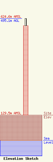
Site Elevation: 129.5 meters (425 ft) |
| Height of Structure: 458.2 meters (1503 feet) |
| Overall Height Above Ground: 495.1 meters (1624 feet) |
| Overall Height Above Mean Sea Level: 624.6 meters (2049 feet) |
| Owner Info | WGME Licensee, LLC
Pillsbury Winthrop Shaw Pittman LLP
Washington, DC 20036
(202) 663-8195
miles.mason@pillsburylaw.com |
| Contact Info | WGME Licensee, LLC
Pillsbury Winthrop Shaw Pittman LLP
Washington, DC 20036
(202) 663-8195
miles.mason@pillsburylaw.com |
