|
|
Antenna Structure Registration 1024421 |
 |
Registration Info | Registration Number: 1024421 |
| File Number: A1351652 |
| FAA Study: 97-ASO-0871-OE |
| FAA Issue Date: 02/09/1998 |
| Status: Constructed |
| Date Constructed: 07/27/1998 |
| FAA EMI: N |
| NEPA: N |
Structure Info
| Structure Type: TOWER |
| Structure Coordinates: 34-14-38.0 N 78-7-23.0 W (NAD 83) |
| Structure Coordinates: 34-14-37.4 N 78-07-24.0 W (Converted to NAD 27) |
| Structure Address: 487 Meters From Int Of Malmo/collon Mintz Rd Brunswick County |
| Structure City: Riegelwood, NC |
| Structure County: Brunswick County |
| Painting & Lighting Info |
FAA Circular #: 70/7460-1J |
FAA Chapters: 3, 4, 5, 13 |
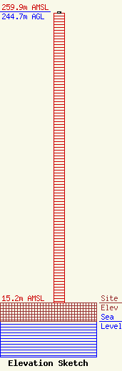
| Elevation Info |
Site Elevation: 15.2 meters (50 ft) |
| Height of Structure: 243.8 meters (800 feet) |
| Overall Height Above Ground: 244.7 meters (803 feet) |
| Overall Height Above Mean Sea Level: 259.9 meters (853 feet) |
| Owner Info | TowerCo VI, LLC
5000 Valleystone Dr
Cary, NC 27519
(919) 653-5700
hbyrne@towerco.com |
| Contact Info | TowerCo VI, LLC
5000 Valleystone Dr
Cary, NC 27519
Henry Byrne
(919) 653-5700
hbyrne@towerco.com |
