|
|
Antenna Structure Registration 1024478 |
 |
Registration Info | Registration Number: 1024478 |
| File Number: A0342649 |
| FAA Study: 88-AGL-1443-OE |
| FAA Issue Date: 10/04/1988 |
| Status: Constructed |
| Date Constructed: 01/01/1991 |
| FAA EMI: N |
| NEPA: N |
Structure Info
| Structure Type: TOWER |
| Structure Coordinates: 45-32-35.0 N 94-15-42.0 W (NAD 83) |
| Structure Coordinates: 45-32-35.1 N 94-15-41.0 W (Converted to NAD 27) |
| Structure Address: 1986 Julep Rd |
| Structure City: Waite Park, MN |
| Structure County: Stearns County |
| Painting & Lighting Info |
FCC Paragraph(s): 1, 3, 4, 13, 21 |
Remarks: RED LIGHTS/PAINT |
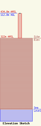
| Elevation Info |
Site Elevation: 322 meters (1056 ft) |
| Height of Structure: 112 meters (367 feet) |
| Overall Height Above Ground: 112.8 meters (370 feet) |
| Overall Height Above Mean Sea Level: 434.8 meters (1427 feet) |
| Owner Info | Starcom, LLC
1986 Julep Road
St. Cloud, MH 56301
(320) 650-1600
|
| Contact Info | Carl E. Smith Consulting Engineers
2324 North Cleveland-Massillon Road
807
Bath, OH 44210-0807
Roy Stype
(330) 659-4440
|
