|
|
Antenna Structure Registration 1024489 |
 |
Registration Info | Registration Number: 1024489 |
| File Number: A1206586 |
| FAA Study: 69-MSP-473-OE |
| FAA Issue Date: 04/07/1970 |
| Status: Constructed |
| Date Constructed: 04/01/1970 |
| NEPA: N |
Structure Info
| Structure Type: TOWER |
| Structure Coordinates: 44-2-31.0 N 91-40-48.0 W (NAD 83) |
| Structure Coordinates: 44-02-31.1 N 91-40-47.5 W (Converted to NAD 27) |
| Structure Address: .7 Km Sw Of Hwy 61 1.4 Km Se Of Hwy 14 |
| Structure City: Winona, MN |
| Structure County: Winona County |
| Painting & Lighting Info |
FCC Paragraph(s): 1, 3, 11, 21 |
Remarks: RED LIGHTS/PAINT |
| Elevation Info |
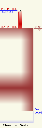
Site Elevation: 367.6 meters (1206 ft) |
| Height of Structure: 75 meters (246 feet) |
| Overall Height Above Ground: 80.8 meters (265 feet) |
| Overall Height Above Mean Sea Level: 448.4 meters (1471 feet) |
| Owner Info | Leighton Radio Holdings, Inc.
1458
St. Cloud, MN 56302
(320) 251-1450
tabfalter@leightonbroadcasting.com |
| Contact Info | Leighton Radio Holdings, Inc.
1458
St. Cloud, MN 56302
Tony Abfalter
(320) 251-1450
tabfalter@leightonbroadcasting.com |
