|
|
Antenna Structure Registration 1024797 |
 |
Registration Info | Registration Number: 1024797 |
| File Number: A1306287 |
| FAA Study: 2020-ASO-37284-OE |
| FAA Issue Date: 12/09/2020 |
| Status: Constructed |
| Date Constructed: 01/01/1972 |
| NEPA: N |
Structure Info
| Structure Type: LTOWER |
| Structure Coordinates: 18-21-20.0 N 64-56-49.0 W (NAD 83) |
| Structure Coordinates: 18-21-27.2 N 64-56-50.5 W (Converted to NAD 27) |
| Structure Address: Atop Signal Hill, 1.3 Miles North Of Charlotte Amalie |
| Structure City: Charlotte Amalie, VI |
| Structure County: St. Thomas Island |
| Painting & Lighting Info |
FAA Chapters: NONE |
Remarks: PRIOR STUDY 2020-ASO-6094-OE |
| Elevation Info |
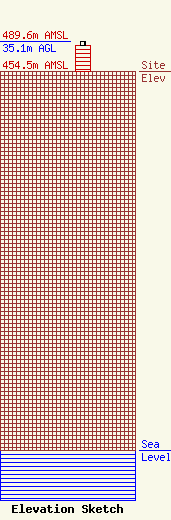
Site Elevation: 454.5 meters (1491 ft) |
| Height of Structure: 30.5 meters (100 feet) |
| Overall Height Above Ground: 35.1 meters (115 feet) |
| Overall Height Above Mean Sea Level: 489.6 meters (1606 feet) |
| Owner Info | Virgin Islands Public Television System
3A-17 Mountain Top
7879
St. Thomas, VI 00801
(340) 718-3339
tsingh@wtjx.org |
| Contact Info | Virgin Islands Public Television System
3A-17 Mountain Top
7879
St. Thomas, VI 00801
Tanya-Marie Singh
(340) 718-3339
tsingh@wtjx.org |
