|
|
Antenna Structure Registration 1024856 |
 |
Registration Info | Registration Number: 1024856 |
| File Number: A1182614 |
| FAA Study: 82-ANE-051-OE |
| FAA Issue Date: 03/22/1982 |
| Status: Dismantled |
| Date Constructed: 01/01/1996 |
| FAA EMI: N |
| NEPA: N |
Structure Info
|
| Structure Coordinates: 42-51-58.0 N 71-17-7.0 W (NAD 83) |
| Structure Coordinates: 42-51-57.7 N 71-17-08.8 W (Converted to NAD 27) |
| Structure Address: Twr 4 - 8 Lawrence Rd |
| Structure City: Derry, NH |
| Structure County: Rockingham County |
| Painting & Lighting Info |
FCC Paragraph(s): 1, 3, 11, 21 |
Remarks: RED LIGHTS/PAINT |
| Elevation Info |
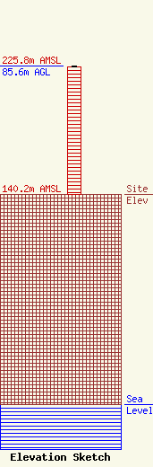
Site Elevation: 140.2 meters (460 ft) |
| Height of Structure: 85 meters (279 feet) |
| Overall Height Above Ground: 85.6 meters (281 feet) |
| Overall Height Above Mean Sea Level: 225.8 meters (741 feet) |
| Owner Info | Blount Communications, Inc.
8 Lawrence Rd
Derry, NH 03038
(603) 437-9337
wblount1590@cs.com |
