|
|
Antenna Structure Registration 1025148 |
 |
Registration Info | Registration Number: 1025148 |
| File Number: A1282317 |
| FAA Study: 98-ANM-0808-OE |
| FAA Issue Date: 09/08/1998 |
| Status: Constructed |
| Date Constructed: 09/08/1998 |
| FAA EMI: N |
| NEPA: N |
Structure Info
| Structure Type: TOWER |
| Structure Coordinates: 39-25-57.0 N 104-39-20.0 W (NAD 83) |
| Structure Coordinates: 39-25-57.0 N 104-39-18.1 W (Converted to NAD 27) |
| Structure Address: 400 Cr # 158 |
| Structure City: Elizabeth, CO |
| Structure County: Elbert County |
| Painting & Lighting Info |
FAA Circular #: 70/7460-1J |
FAA Chapters: 3, 4, 5, 13 |
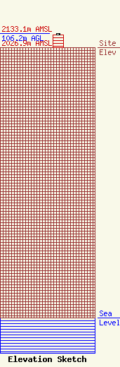
| Elevation Info |
Site Elevation: 2026.9 meters (6650 ft) |
| Height of Structure: 94.6 meters (310 feet) |
| Overall Height Above Ground: 106.2 meters (348 feet) |
| Overall Height Above Mean Sea Level: 2133.1 meters (6998 feet) |
| Owner Info | MediaCo Operations LLC
48 West 25th Street
New York, NY 10010
(202) 663-8167
scott.flick@pillsburylaw.com |
| Contact Info | Pillsbury Winthrop Shaw Pittman LLP
1200 Seventeenth Street, NW
Washington, DC 20036
Scott Flick
(202) 663-8167
scott.flick@pillsburylaw.com |
