|
|
Antenna Structure Registration 1025374 |
 |
Registration Info | Registration Number: 1025374 |
| File Number: A1381626 |
| FAA Study: 71-GL-354-OE |
| FAA Issue Date: 08/02/1971 |
| Status: Constructed |
| Date Constructed: 04/01/1973 |
| NEPA: N |
Structure Info
| Structure Type: TOWER |
| Structure Coordinates: 40-23-20.0 N 86-36-46.0 W (NAD 83) |
| Structure Coordinates: 40-23-19.9 N 86-36-46.0 W (Converted to NAD 27) |
| Structure Address: Int 600w & 700n |
| Structure City: Rossville, IN |
| Structure County: Clinton County |
| Painting & Lighting Info |
FCC Paragraph(s): 1, 3, 6, 15, 21 |
Remarks: RED LIGHTS/PAINT |
| Elevation Info |
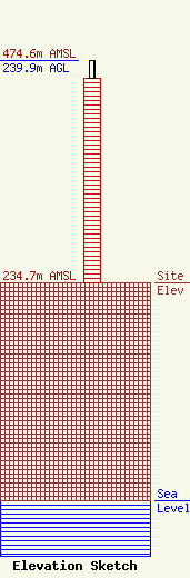
Site Elevation: 234.7 meters (770 ft) |
| Height of Structure: 220.7 meters (724 feet) |
| Overall Height Above Ground: 239.9 meters (787 feet) |
| Overall Height Above Mean Sea Level: 474.6 meters (1557 feet) |
| Owner Info | Gray Local Media, Inc.
4370 Peachtree Road, NE
Atlanta, GA 30319
(404) 504-9828
rob.folliard@graymedia.com |
| Contact Info | Cooley LLP
1299 Pennsylvania Avenue, NW
Washington, DC 20004
Henry Wendel
(202) 776-2943
hwendel@cooley.com |
