|
|
Antenna Structure Registration 1026187 |
 |
Registration Info | Registration Number: 1026187 |
| File Number: A1258360 |
| FAA Study: 2013-ACE-2164-OE |
| FAA Issue Date: 10/24/2013 |
| Status: Constructed |
| Date Constructed: 02/01/2014 |
| FAA EMI: N |
| NEPA: N |
Structure Info
| Structure Type: LTOWER |
| Structure Coordinates: 41-15-30.0 N 95-57-6.0 W (NAD 83) |
| Structure Coordinates: 41-15-30.0 N 95-57-04.9 W (Converted to NAD 27) |
| Structure Address: 2665 Douglas St |
| Structure City: Omaha, NE |
| Structure County: Douglas County |
| Painting & Lighting Info |
FAA Circular #: 70/7460-1K |
FAA Chapters: 4, 8, 12 |
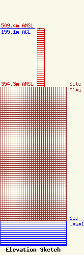
| Elevation Info |
Site Elevation: 354.3 meters (1162 ft) |
| Height of Structure: 155.1 meters (509 feet) |
| Overall Height Above Ground: 155.1 meters (509 feet) |
| Overall Height Above Mean Sea Level: 509.4 meters (1671 feet) |
| Owner Info | Hearst Properties Inc.
1800
Raleigh, NC 27602
(919) 839-0300
shartzell@brookspierce.com |
| Contact Info | KETV
1001 S. 10th Street
Omaha, NE 68108-3209
Brady Pedersen
(402) 978-8912
bpedersen@hearst.com |
