|
|
Antenna Structure Registration 1026935 |
 |
Registration Info | Registration Number: 1026935 |
| File Number: A1349796 |
| FAA Study: 2025-AEA-2411-OE |
| FAA Issue Date: 04/03/2025 |
| Status: Constructed |
| Date Constructed: 10/01/1982 |
| NEPA: N |
Structure Info
| Structure Type: LTOWER |
| Structure Coordinates: 40-5-0.5 N 74-55-6.7 W (NAD 83) |
| Structure Coordinates: 40-05-00.1 N 74-55-08.1 W (Converted to NAD 27) |
| Structure Address: 777 Winks Lane (pa15843-a) |
| Structure City: Bensalem, PA |
| Structure County: Bucks County |
| Painting & Lighting Info |
FAA Circular #: 70/7460-1M |
FAA Chapters: 4, 8, 15 |
Remarks: PRIOR STUDY 2022-AEA-1534-OE |
| Elevation Info |
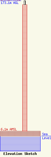
Site Elevation: 6.1 meters (20 ft) |
| Height of Structure: 167.9 meters (551 feet) |
| Overall Height Above Ground: 173.1 meters (568 feet) |
| Overall Height Above Mean Sea Level: 179.2 meters (588 feet) |
| Owner Info | SBA Towers V, LLC
8051 Congress Avenue
Boca Raton, FL 33487
(561) 995-7670
ERoach@sbasite.com |
| Contact Info | SBA Towers V, LLC
8051 Congress Avenue
Boca Raton, FL 33487
(561) 995-7670
ERoach@sbasite.com |
