|
|
Antenna Structure Registration 1026937 |
 |
Registration Info | Registration Number: 1026937 |
| File Number: A1178603 |
| FAA Study: 96-ASW-0786-OE |
| FAA Issue Date: 05/23/1996 |
| Status: Constructed |
| Date Constructed: 11/17/1997 |
| FAA EMI: N |
| NEPA: N |
Structure Info
| Structure Type: TOWER |
| Structure Coordinates: 34-53-33.0 N 92-24-51.0 W (NAD 83) |
| Structure Coordinates: 34-53-32.7 N 92-24-50.4 W (Converted to NAD 27) |
| Structure Address: Garot Road |
| Structure City: Maumelle, AR |
| Structure County: Pulaski County |
| Painting & Lighting Info |
FAA Circular #: 70/7460-1J |
FAA Chapters: 3, 4, 5, 13 |
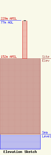
| Elevation Info |
Site Elevation: 152 meters (499 ft) |
| Height of Structure: 76 meters (249 feet) |
| Overall Height Above Ground: 77 meters (253 feet) |
| Overall Height Above Mean Sea Level: 229 meters (751 feet) |
| Owner Info | Educational Media Foundation
5700 West Oaks Blvd
Rocklin, CA 95765
(916) 251-1600
jmiller@kloveair1.com |
| Contact Info | Educational Media Foundation
5700 West Oaks Blvd
Rocklin, CA 95765
(916) 251-1600
jmiller@kloveair1.com |
