|
|
Antenna Structure Registration 1027224 |
 |
Registration Info | Registration Number: 1027224 |
| File Number: A0740398 |
| FAA Study: 97-AGL-5216-OE |
| FAA Issue Date: 02/18/1998 |
| Status: Constructed |
| Date Constructed: 01/01/1991 |
| FAA EMI: N |
| NEPA: N |
Structure Info
| Structure Type: 2TOWER |
| Structure Coordinates: 39-45-59.0 N 86-7-46.0 W (NAD 83) |
| Structure Coordinates: 39-45-58.8 N 86-07-46.1 W (Converted to NAD 27) |
| Structure Address: 47 S State Ave |
| Structure City: Indianapolis, IN |
| Structure County: Marion County |
| Painting & Lighting Info |
FAA Circular #: 70/7460-1J |
FAA Chapters: 3, 4, 5, 13 |
| Elevation Info |
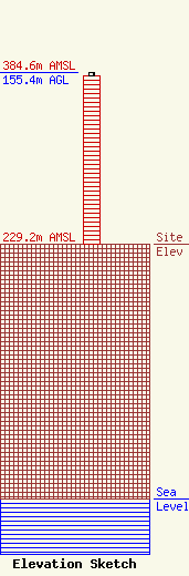
Site Elevation: 229.2 meters (752 ft) |
| Height of Structure: 152.4 meters (500 feet) |
| Overall Height Above Ground: 155.4 meters (510 feet) |
| Overall Height Above Mean Sea Level: 384.7 meters (1262 feet) |
| Owner Info | INDIANAPOLIS DIVISION OF PUBLIC SAFETY COMMUNICATIONS
47 SOUTH STATE AVENUE
INDIANAPOLIS, IN 46201
(317) 327-7315
DAVID.SCHWARTZ@INDY.GOV |
