|
|
Antenna Structure Registration 1027317 |
 |
Registration Info | Registration Number: 1027317 |
| File Number: A0699594 |
| Status: Dismantled |
| Date Constructed: 01/01/1962 |
| FAA EMI: N |
| NEPA: N |
Structure Info
| Structure Type: TOWER |
| Structure Coordinates: 26-35-18.0 N 80-12-29.0 W (NAD 83) |
| Structure Coordinates: 26-35-16.8 N 80-12-29.8 W (Converted to NAD 27) |
| Structure Address: 6011 State Rd 7 Near |
| Structure City: West Palm Beach, FL |
| Structure County: Palm Beach County |
| Painting & Lighting Info |
FCC Paragraph(s): 1, 3, 7, 16, 21 |
| Elevation Info |
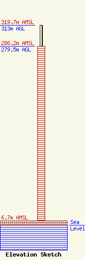
Site Elevation: 6.7 meters (22 ft) |
| Height of Structure: 279.5 meters (917 feet) |
| Overall Height Above Ground: 313 meters (1027 feet) |
| Overall Height Above Mean Sea Level: 319.7 meters (1049 feet) |
| Owner Info | Freedom Broadcasting of Florida Licensee LLC
1100 Fairfield Drive
West Palm Beach, FL 33407
(561) 544-1212
|
| Contact Info | Wilmer Cutler Pickering Hale and Dorr LLP
1875 Pennsylvania Avenue, NW
Washington, DC 20006
Jack Goodman
(202) 663-6287
jack.goodman@wilmerhale.com |
