|
|
Antenna Structure Registration 1027466 |
 |
Registration Info | Registration Number: 1027466 |
| File Number: A0032587 |
| FAA Study: 97-AEA-1001-OE |
| Status: Constructed |
| Date Constructed: 08/24/1984 |
| NEPA: N |
Structure Info
| Structure Type: TOWER |
| Structure Coordinates: 37-23-6.0 N 77-3-38.0 W (NAD 83) |
| Structure Coordinates: 37-23-05.5 N 77-03-39.1 W (Converted to NAD 27) |
| Structure Address: 1201 Munford Rd On Rt 600 .25 Mi From Rt 155 |
| Structure City: Charles City, VA |
| Structure County: Charles City County |
| Painting & Lighting Info |
FAA Circular #: 70/7460-1J |
FAA Chapters: 3, 4, 5, 13 |
| Elevation Info |
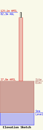
Site Elevation: 37.8 meters (124 ft) |
| Height of Structure: 76.2 meters (250 feet) |
| Overall Height Above Ground: 82.3 meters (270 feet) |
| Overall Height Above Mean Sea Level: 120.1 meters (394 feet) |
| Owner Info | HAMPTON ROADS EDUCATIONAL TELECOMMUNICATIONS ASSOCIATION INC DBA = WHRO
5200 HAMPTON BLVD
NORFOLK, VA 23508
(757) 889-9400
KMASSIE@WHRO.ORG |
