|
|
Antenna Structure Registration 1027472 |
 |
Registration Info | Registration Number: 1027472 |
| File Number: A0692621 |
| FAA Study: 97-AEA-1009-OE |
| FAA Issue Date: 06/11/1997 |
| Status: Constructed |
| Date Constructed: 03/03/2010 |
| FAA EMI: N |
| NEPA: N |
Structure Info
| Structure Type: TOWER |
| Structure Coordinates: 36-53-23.0 N 76-18-6.0 W (NAD 83) |
| Structure Coordinates: 36-53-22.5 N 76-18-07.2 W (Converted to NAD 27) |
| Structure Address: 5200 Hampton Blvd |
| Structure City: Norfolk, VA |
| Structure County: Norfolk city |
| Painting & Lighting Info |
FAA Chapters: NONE |
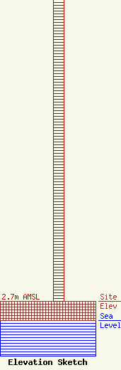
| Elevation Info |
Site Elevation: 2.7 meters (9 ft) |
| Height of Structure: 55.2 meters (181 feet) |
| Overall Height Above Ground: 55.2 meters (181 feet) |
| Overall Height Above Mean Sea Level: 57.9 meters (190 feet) |
| Owner Info | HAMPTON ROADS EDUCATIONAL TELECOMMUNICATIONS ASSOCIATION INC DBA = WHRO
5200 HAMPTON BLVD
NORFOLK, VA 23508
(757) 889-9400
chrisg@whro.org |
