|
|
Antenna Structure Registration 1027749 |
 |
Registration Info | Registration Number: 1027749 |
| File Number: A1251867 |
| FAA Study: 2022-AGL-24211-OE |
| FAA Issue Date: 02/09/2023 |
| Status: Constructed |
| Date Constructed: 01/01/1974 |
| NEPA: N |
Structure Info
| Structure Type: GTOWER |
| Structure Coordinates: 47-29-17.1 N 92-31-14.2 W (NAD 83) |
| Structure Coordinates: 47-29-17.4 N 92-31-13.5 W (Converted to NAD 27) |
| Structure Address: 201 Lynne Dr. (mn20761-a) |
| Structure City: Virginia, MN |
| Structure County: St. Louis County |
| Painting & Lighting Info |
FAA Circular #: 70/7460-1K |
FAA Chapters: 4, 8, 12 |
Remarks: PRIOR STUDY 2012-AGL-6590-OE |
Remarks: OM&L to remain the same as prior study = A MED-DUAL SYSTEM |
Remarks: PRIOR STUDY 2012-AGL-6590-OE |
| Elevation Info |
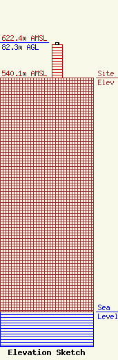
Site Elevation: 540.1 meters (1772 ft) |
| Height of Structure: 76.2 meters (250 feet) |
| Overall Height Above Ground: 82.3 meters (270 feet) |
| Overall Height Above Mean Sea Level: 622.4 meters (2042 feet) |
| Owner Info | SBA Structures, LLC
8051 Congress Avenue
Boca Raton, FL 34487
(561) 995-7670
ERoach@sbasite.com |
| Contact Info | SBA Structures, LLC
8051 Congress Avenue
Boca Raton, FL 33487
(561) 995-7670
ERoach@sbasite.com |
