|
|
Antenna Structure Registration 1027916 |
 |
Registration Info | Registration Number: 1027916 |
| File Number: A1163617 |
| FAA Study: 97-AGL-2934-OE |
| FAA Issue Date: 07/22/1997 |
| Status: Constructed |
| Date Constructed: 01/01/1971 |
| NEPA: N |
Structure Info
| Structure Type: TOWER |
| Structure Coordinates: 38-32-31.0 N 89-36-47.0 W (NAD 83) |
| Structure Coordinates: 38-32-30.8 N 89-36-46.7 W (Converted to NAD 27) |
| Structure Address: On S. Commercial St., 1 Blk S Of Int. Of Sr161 & Commercial St. |
| Structure City: Albers, IL |
| Structure County: Clinton County |
| Painting & Lighting Info |
FAA Circular #: 70/7460-1J |
FAA Chapters: 4, 6, 13 |
| Elevation Info |
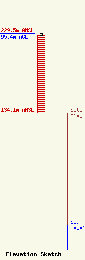
Site Elevation: 134.1 meters (440 ft) |
| Height of Structure: 93.3 meters (306 feet) |
| Overall Height Above Ground: 95.4 meters (313 feet) |
| Overall Height Above Mean Sea Level: 229.5 meters (753 feet) |
| Owner Info | Norfolk Southern Corporation
1200 Peachtree ST NE
Atlanta, GA 30309
(404) 582-6244
brian.smith7@nscorp.com |
| Contact Info | Norfolk Southern Corporation
1200 Peachtree St NE
Atlanta, GA 30309
Brian Smith
(404) 582-6244
brian.smith7@nscorp.com |
