|
|
Antenna Structure Registration 1028050 |
 |
Registration Info | Registration Number: 1028050 |
| File Number: A0974453 |
| FAA Study: 2015-AGL-6618-OE |
| FAA Issue Date: 06/30/2015 |
| Status: Granted |
| Date Constructed: 01/01/1991 |
| NEPA: N |
Structure Info
| Structure Type: GTOWER |
| Structure Coordinates: 38-43-45.3 N 87-24-46.2 W (NAD 83) |
| Structure Coordinates: 38-43-45.1 N 87-24-46.1 W (Converted to NAD 27) |
| Structure Address: Rr 1 Box 231b 1 Mi S Of Bruceville |
| Structure City: Vincennes, IN |
| Structure County: Knox County |
| Painting & Lighting Info |
FAA Circular #: 70/7460-1K |
FAA Chapters: 3, 4, 5, 9 |
Remarks: FAA CHAPTERS 3,4,5,9; 70/7460-1K WITH FAA APPROVED BIRD DEVIATION SPECIAL CONDITION. PRIOR STUDY 1992-AGL-753-OE. |
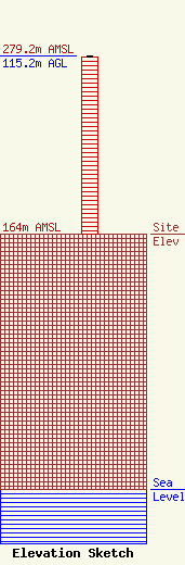
| Elevation Info |
Site Elevation: 164 meters (538 ft) |
| Height of Structure: 114.3 meters (375 feet) |
| Overall Height Above Ground: 115.2 meters (378 feet) |
| Overall Height Above Mean Sea Level: 279.2 meters (916 feet) |
| Owner Info | The Original Company, Inc.
1309 Old Orchard Road
242
Vincennes, IN 47591
(812) 882-6060
marklange@originalcompany.com |
| Contact Info | The Original Company, Inc.
1309 Old Orchard Road
242
Vincennes, IN 47591
(812) 882-6060
marklange@originalcompany.com |
