|
|
Antenna Structure Registration 1028110 |
 |
Registration Info | Registration Number: 1028110 |
| File Number: A1367022 |
| FAA Study: 2010-ASO-6857-OE |
| FAA Issue Date: 01/24/2011 |
| Status: Constructed |
| Date Constructed: 05/16/1997 |
| FAA EMI: N |
| NEPA: N |
Structure Info
| Structure Type: TOWER |
| Structure Coordinates: 33-36-27.0 N 84-54-12.0 W (NAD 83) |
| Structure Coordinates: 33-36-26.6 N 84-54-12.2 W (Converted to NAD 27) |
| Structure Address: Hwy 166 @ Carroll Douglas Cty Line |
| Structure City: Fairplay, GA |
| Structure County: Douglas County |
| Painting & Lighting Info |
FAA Circular #: 70/7460-1K |
FAA Chapters: 3, 4, 5, 12 |
Remarks: PRIOR STUDY 2008-ASO-2375-OE |
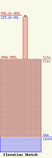
| Elevation Info |
Site Elevation: 384 meters (1260 ft) |
| Height of Structure: 207.9 meters (682 feet) |
| Overall Height Above Ground: 215.2 meters (706 feet) |
| Overall Height Above Mean Sea Level: 599.2 meters (1966 feet) |
| Owner Info | Pinnacle Towers LLC
2000 Corporate Drive
Canonsburg, PA 15317
(724) 416-2400
Regulatory.Department@crowncastle.com |
| Contact Info | Crown Castle
2000 Corporate Drive
Canonsburg, PA 15317
Tom Anderson
(724) 743-6330
Tom.Anderson@crowncastle.com |
