|
|
Antenna Structure Registration 1028212 |
 |
Registration Info | Registration Number: 1028212 |
| File Number: A1069099 |
| FAA Study: 2004-AGL-6978-OE |
| FAA Issue Date: 02/14/2005 |
| Status: Constructed |
| Date Constructed: 05/10/1985 |
| FAA EMI: N |
| NEPA: N |
Structure Info
| Structure Type: TOWER |
| Structure Coordinates: 41-6-24.3 N 85-11-45.7 W (NAD 83) |
| Structure Coordinates: 41-06-24.1 N 85-11-45.8 W (Converted to NAD 27) |
| Structure Address: 3431 Hillegas Road (fort Wayne-hillegas# 90138) |
| Structure City: Fort Wayne, IN |
| Structure County: Allen County |
| Painting & Lighting Info |
FAA Circular #: 70/7460-1K |
FAA Chapters: 3, 4, 5, 12 |
Remarks: PRIOR STUDY 2004-AGL-6527-OE |
| Elevation Info |
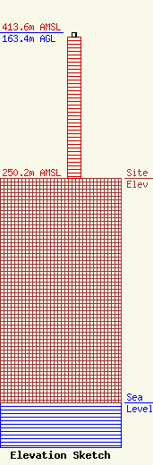
Site Elevation: 250.2 meters (821 ft) |
| Height of Structure: 158.5 meters (520 feet) |
| Overall Height Above Ground: 163.4 meters (536 feet) |
| Overall Height Above Mean Sea Level: 413.6 meters (1357 feet) |
| Info |
| Info |
