|
|
Antenna Structure Registration 1028315 |
 |
Registration Info | Registration Number: 1028315 |
| File Number: A0917575 |
| FAA Study: 2009-ANM-614-OE |
| FAA Issue Date: 04/22/2009 |
| Status: Constructed |
| Date Constructed: 04/01/1995 |
| FAA EMI: N |
| NEPA: N |
Structure Info
| Structure Type: TOWER |
| Structure Coordinates: 46-14-3.6 N 119-19-17.4 W (NAD 83) |
| Structure Coordinates: 46-14-04.1 N 119-19-13.3 W (Converted to NAD 27) |
| Structure Address: 2.9 Km W Of Intersection Of Keene And Brantingham |
| Structure City: Kennewick, WA |
| Structure County: Benton County |
| Painting & Lighting Info |
FAA Chapters: NONE |
Remarks: PRIOR STUDY 1997-ANM-547-OE |
| Elevation Info |
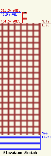
Site Elevation: 484.6 meters (1590 ft) |
| Height of Structure: 46.9 meters (154 feet) |
| Overall Height Above Ground: 46.9 meters (154 feet) |
| Overall Height Above Mean Sea Level: 531.5 meters (1744 feet) |
| Owner Info | Global Tower, LLC. through American Towers, LLC
10 Presidential Way
Woburn, MA 01801
(678) 564-3236
faa-fcc@americantower.com |
| Contact Info | American Towers, LLC.
10 Presidential Way
Woburn, MA 01801
(678) 564-3236
faa-fcc@americantower.com |
