|
|
Antenna Structure Registration 1028413 |
 |
Registration Info | Registration Number: 1028413 |
| File Number: A1264033 |
| FAA Study: 2023-AGL-21883-OE |
| FAA Issue Date: 11/20/2023 |
| Status: Constructed |
| Date Constructed: 12/14/2023 |
| NEPA: N |
Structure Info
| Structure Type: GTOWER |
| Structure Coordinates: 37-59-17.8 N 87-35-50.4 W (NAD 83) |
| Structure Coordinates: 37-59-17.6 N 87-35-50.3 W (Converted to NAD 27) |
| Structure Address: 1162 Mount Auburn Rd |
| Structure City: Evansville, IN |
| Structure County: Vanderburgh County |
| Painting & Lighting Info |
FAA Circular #: 70/7460-1M |
FAA Chapters: 4, 8, 15 |
Remarks: PRIOR STUDY 2006-AGL-3695-OE |
| Elevation Info |
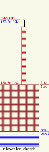
Site Elevation: 128.3 meters (421 ft) |
| Height of Structure: 158.5 meters (520 feet) |
| Overall Height Above Ground: 177.7 meters (583 feet) |
| Overall Height Above Mean Sea Level: 306 meters (1004 feet) |
| Owner Info | Midwest Communications, Inc
904 Grand Ave.
Wausau, WI 54403
(715) 842-1437
paul.rahmlow@mwcradio.com |
| Info |
