|
|
Antenna Structure Registration 1028674 |
 |
Registration Info | Registration Number: 1028674 |
| File Number: A1137539 |
| FAA Study: 2014-AEA-7150-OE |
| FAA Issue Date: 03/10/2016 |
| Status: Constructed |
| Date Constructed: 01/01/1996 |
Structure Info
| Structure Type: GTOWER |
| Structure Coordinates: 43-24-56.0 N 76-27-53.0 W (NAD 83) |
| Structure Coordinates: 43-24-55.8 N 76-27-54.2 W (Converted to NAD 27) |
| Structure Address: St Rt 481 At Dutch Ridge Rd |
| Structure City: Oswego, NY |
| Structure County: Oswego County |
| Painting & Lighting Info |
FAA Circular #: 70/7460-1L |
FAA Chapters: 4, 8, 12 |
Remarks: PRIOR STUDY 1996-AEA-367-OE |
Remarks: OM&L to remain the same as prior study = PAINT/RED LIGHTS |
Remarks: PRIOR STUDY 1996-AEA-367-OE |
Remarks: OM&L to remain the same as prior study = PAINT/RED LIGHTS |
| Elevation Info |
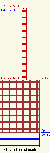
Site Elevation: 106.7 meters (350 ft) |
| Height of Structure: 146.9 meters (482 feet) |
| Overall Height Above Ground: 146.9 meters (482 feet) |
| Overall Height Above Mean Sea Level: 253.6 meters (832 feet) |
| Owner Info | PTI US Assets I, LLC
999 Yamato Road
Boca Raton, FL 33431
(561) 257-0557
smoras@phoenixintnl.com |
| Contact Info | PTI US Assets I, LLC
999 Yamato Road
Boca Raton, FL 33431
(561) 257-0557
smoras@phoenixintnl.com |
