|
|
Antenna Structure Registration 1029017 |
 |
Registration Info | Registration Number: 1029017 |
| File Number: A1297334 |
| FAA Study: 2018-ASO-3400-OE |
| FAA Issue Date: 03/07/2018 |
| Status: Granted |
| Date Constructed: 01/01/1962 |
| NEPA: N |
Structure Info
| Structure Type: GTOWER |
| Structure Coordinates: 30-26-0.0 N 85-24-51.0 W (NAD 83) |
| Structure Coordinates: 30-25-59.3 N 85-24-51.3 W (Converted to NAD 27) |
| Structure Address: 12544 Highway 20 |
| Structure City: Youngstown, FL |
| Structure County: Bay County |
| Painting & Lighting Info |
FAA Circular #: 70/7460-1L |
FAA Chapters: 4, 7, 12 |
Remarks: Removed expiration date from determination. Scenario 1./jjs/case#635066 |
Remarks: PRIOR STUDY 2011-ASO-1314-OE |
Remarks: Removed expiration date from determination. Scenario 1./jjs/case#635066 |
Remarks: PRIOR STUDY 2011-ASO-1314-OE |
| Elevation Info |
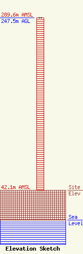
Site Elevation: 42.1 meters (138 ft) |
| Height of Structure: 247.5 meters (812 feet) |
| Overall Height Above Ground: 247.5 meters (812 feet) |
| Overall Height Above Mean Sea Level: 289.6 meters (950 feet) |
| Owner Info | Gray Local Media, Inc.
4370 Peachtree Road, NE
Atlanta, GA 30319
(404) 266-8333
legalnotices@graymedia.com |
| Contact Info | Gray Local Media, Inc.
4370 Peachtree Road NE
Atlanta, GA 30319
Engineering Department
(404) 266-8333
legalnotices@graymedia.com |
