|
|
Antenna Structure Registration 1029036 |
 |
Registration Info | Registration Number: 1029036 |
| File Number: A0034464 |
| FAA Study: 75-GL-12-OE |
| FAA Issue Date: 03/18/1975 |
| Status: Constructed |
| Date Constructed: 01/01/1975 |
| NEPA: N |
Structure Info
| Structure Type: TOWER |
| Structure Coordinates: 40-1-2.0 N 83-1-11.0 W (NAD 83) |
| Structure Coordinates: 40-01-01.8 N 83-01-11.3 W (Converted to NAD 27) |
| Structure Address: 350 W Dodridge St |
| Structure City: Columbus, OH |
| Structure County: Franklin County |
| Painting & Lighting Info |
FCC Paragraph(s): 1, 3, 5, 14, 21 |
Remarks: RED LIGHTS/PAINT |
| Elevation Info |
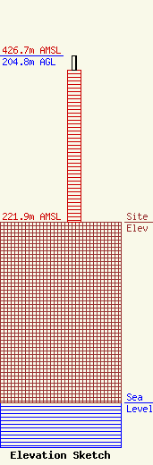
Site Elevation: 221.9 meters (728 ft) |
| Height of Structure: 186.8 meters (613 feet) |
| Overall Height Above Ground: 204.8 meters (672 feet) |
| Overall Height Above Mean Sea Level: 426.7 meters (1400 feet) |
| Owner Info | OHIO STATE UNIVERSITY DBA = WOSU STATIONS
2400 OLENTANGY RIVER RD
COLUMBUS, OH 43210
(614) 292-9678
|
