|
|
Antenna Structure Registration 1029211 |
 |
Registration Info | Registration Number: 1029211 |
| File Number: A0034658 |
| FAA Study: 97-AWP-0931-OE |
| FAA Issue Date: 04/17/1997 |
| Status: Constructed |
| Date Constructed: 01/01/1997 |
| NEPA: N |
Structure Info
| Structure Type: 4TA1 |
| Structure Coordinates: 34-7-7.0 N 118-4-59.0 W (NAD 83) |
| Structure Coordinates: 34-07-07.0 N 118-04-55.8 W (Converted to NAD 27) |
| Structure Address: Twr 1 - 6544 N Vista St |
| Structure City: San Gabriel, CA |
| Structure County: Los Angeles County |
| Painting & Lighting Info |
FAA Circular #: |
FAA Chapters: NONE |
Remarks: 4 TOWER ARRAY. TOWER 3 HAD RED LIGHTS/PAINT. TOWERS 1, 2 & 4 HAVE NO OM&L. |
| Elevation Info |
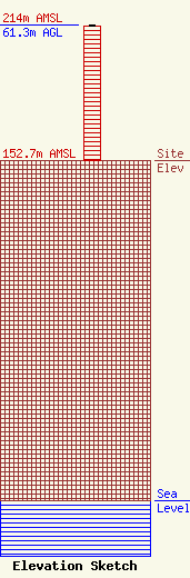
Site Elevation: 152.7 meters (501 ft) |
| Height of Structure: 60.4 meters (198 feet) |
| Overall Height Above Ground: 61.3 meters (201 feet) |
| Overall Height Above Mean Sea Level: 214 meters (702 feet) |
| Owner Info | POLYETHNIC BROADCASTING INC DBA = RADIO STATION KALI
747 E GREEN ST
PASADENA, CA 91101
(626) 844-8882
|
