|
|
Antenna Structure Registration 1029311 |
 |
Registration Info | Registration Number: 1029311 |
| File Number: A0934433 |
| FAA Study: 2014-ASO-13280-OE |
| FAA Issue Date: 01/16/2015 |
| Status: Constructed |
| Date Constructed: 01/01/1988 |
| NEPA: N |
Structure Info
| Structure Type: GTOWER |
| Structure Coordinates: 27-7-19.0 N 80-23-41.0 W (NAD 83) |
| Structure Coordinates: 27-07-17.8 N 80-23-41.8 W (Converted to NAD 27) |
| Structure Address: 7325 Sw Allapattah Road |
| Structure City: Indiantown, FL |
| Structure County: Martin County |
| Painting & Lighting Info |
FAA Circular #: 70/7460-1K |
FAA Chapters: 4, 7, 12 |
Remarks: PRIOR STUDY 1998-ASO-3309-OE |
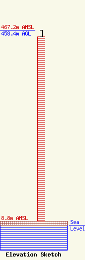
| Elevation Info |
Site Elevation: 8.8 meters (29 ft) |
| Height of Structure: 442.7 meters (1452 feet) |
| Overall Height Above Ground: 458.4 meters (1504 feet) |
| Overall Height Above Mean Sea Level: 467.2 meters (1533 feet) |
| Owner Info | Hearst Properties Inc.
1800
Raleigh, NC 27602
(919) 839-0300
mprak@brookspierce.com |
| Info |
