|
|
Antenna Structure Registration 1029367 |
 |
Registration Info | Registration Number: 1029367 |
| File Number: A0034823 |
| FAA Study: 95-ACE-0108-OE |
| FAA Issue Date: 05/02/1995 |
| Status: Constructed |
| Date Constructed: 03/10/1996 |
| NEPA: N |
Structure Info
| Structure Type: TOWER |
| Structure Coordinates: 38-52-50.0 N 97-12-41.0 W (NAD 83) |
| Structure Coordinates: 38-52-50.0 N 97-12-39.9 W (Converted to NAD 27) |
| Structure Address: 4.8 Km South Of Abilene On Hwy K15 |
| Structure City: Abilene, KS |
| Structure County: Dickinson County |
| Painting & Lighting Info |
FAA Chapters: None |
| Elevation Info |
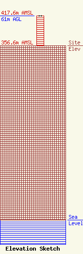
Site Elevation: 356.6 meters (1170 ft) |
| Height of Structure: 61 meters (200 feet) |
| Overall Height Above Ground: 61 meters (200 feet) |
| Overall Height Above Mean Sea Level: 417.6 meters (1370 feet) |
| Owner Info | WESTERN RESOURCES INC
818 KANSAS AVENUE
889
TOPEKA, KS 66601
(913) 575-6560
STEVE_INGERSOLL@WSTNRES.COM |
