|
|
Antenna Structure Registration 1029604 |
 |
Registration Info | Registration Number: 1029604 |
| File Number: A1206021 |
| FAA Study: 2014-ASO-8960-OE |
| FAA Issue Date: 10/09/2014 |
| Status: Constructed |
| Date Constructed: 11/25/1977 |
| NEPA: N |
Structure Info
| Structure Type: GTOWER |
| Structure Coordinates: 25-57-31.0 N 80-12-43.0 W (NAD 83) |
| Structure Coordinates: 25-57-29.7 N 80-12-43.8 W (Converted to NAD 27) |
| Structure Address: 695 Nw 199th St |
| Structure City: Miami, FL |
| Structure County: Miami-Dade County |
| Painting & Lighting Info |
FAA Circular #: 70/7460-1K |
FAA Chapters: 3, 4, 5, 12 |
| Elevation Info |
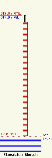
Site Elevation: 1.9 meters (6 ft) |
| Height of Structure: 299.2 meters (982 feet) |
| Overall Height Above Ground: 317.9 meters (1043 feet) |
| Overall Height Above Mean Sea Level: 319.8 meters (1049 feet) |
| Owner Info | American Towers LLC
10 Presidential Way
Woburn, MA 01801
(781) 926-4500
faa-fcc@americantower.com |
| Contact Info | American Towers LLC
10 Presidential Way
Woburn, MA 01801
(781) 926-4500
faa-fcc@americantower.com |
