|
|
Antenna Structure Registration 1029781 |
 |
Registration Info | Registration Number: 1029781 |
| File Number: A0035287 |
| Status: Constructed |
| Date Constructed: 01/01/1948 |
| NEPA: N |
Structure Info
| Structure Type: TOWER |
| Structure Coordinates: 38-39-4.0 N 87-9-55.0 W (NAD 83) |
| Structure Coordinates: 38-39-03.8 N 87-09-55.0 W (Converted to NAD 27) |
| Structure Address: Se 11th St |
| Structure City: Washington, IN |
| Structure County: Daviess County |
| Painting & Lighting Info |
FCC Paragraph(s): 1, 3, 12, 21 |
| Elevation Info |
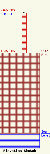
Site Elevation: 163 meters (535 ft) |
| Height of Structure: 81 meters (266 feet) |
| Overall Height Above Ground: 83 meters (272 feet) |
| Overall Height Above Mean Sea Level: 246 meters (807 feet) |
| Owner Info | OLD NORTHWEST BROADCASTING INC
242
VINCENNES, IN 47591
(812) 882-6060
WAOV@NS.KENSCO.NET |
