|
|
Antenna Structure Registration 1029950 |
 |
Registration Info | Registration Number: 1029950 |
| File Number: A1065126 |
| Status: Constructed |
| Date Constructed: 01/01/1954 |
| FAA EMI: N |
| NEPA: N |
Structure Info
| Structure Type: TOWER |
| Structure Coordinates: 39-27-57.0 N 87-24-12.0 W (NAD 83) |
| Structure Coordinates: 39-27-56.9 N 87-24-11.9 W (Converted to NAD 27) |
| Structure Address: 918 Ohio St |
| Structure City: Terre Haute, IN |
| Structure County: Vigo County |
| Painting & Lighting Info |
FCC Paragraph(s): 1, 3, 4, 13, 21 |
| Elevation Info |
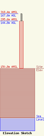
Site Elevation: 150.8 meters (495 ft) |
| Height of Structure: 144.8 meters (475 feet) |
| Overall Height Above Ground: 167.6 meters (550 feet) |
| Overall Height Above Mean Sea Level: 318.4 meters (1045 feet) |
| Owner Info | Midwest Communications, Inc WTHI
904 Grand Ave.
Wausau, WI 54403
(715) 842-1437
paul.rahmlow@mwcradio.com |
| Contact Info | Midwest Communications, Inc WTHI
904 Grand Ave.
Wausau, WI 54403
(715) 842-1437
paul.rahmlow@mwcradio.com |
