|
|
Antenna Structure Registration 1029954 |
 |
Registration Info | Registration Number: 1029954 |
| File Number: A1381630 |
| FAA Study: 2016-AGL-6656-OE |
| FAA Issue Date: 05/18/2016 |
| Status: Constructed |
| Date Constructed: 04/14/2022 |
| NEPA: N |
Structure Info
| Structure Type: GTOWER |
| Structure Coordinates: 39-14-32.7 N 87-23-5.7 W (NAD 83) |
| Structure Coordinates: 39-14-32.6 N 87-23-05.6 W (Converted to NAD 27) |
| Structure Address: Approx. 0.4 Miles South Of Farmersburg, In. And 0.2 Miles East Of Us Highway 41 |
| Structure City: Farmersburg, IN |
| Structure County: Sullivan County |
| Painting & Lighting Info |
FAA Circular #: 70/7460-1J |
FAA Chapters: 3, 4, 5, 13 |
Remarks: PRIOR STUDY 1997-AGL-3655-OE |
Remarks: OM&L to remain the same as prior study = PAINT/RED LIGHTS |
Remarks: PRIOR STUDY 1997-AGL-3655-OE |
| Elevation Info |
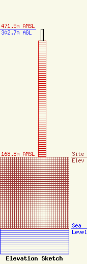
Site Elevation: 168.8 meters (554 ft) |
| Height of Structure: 274.3 meters (900 feet) |
| Overall Height Above Ground: 302.7 meters (993 feet) |
| Overall Height Above Mean Sea Level: 471.5 meters (1547 feet) |
| Owner Info | Gray Local Media, Inc.
4370 Peachtree Road, NE
Atlanta, GA 30319
(404) 504-9828
rob.folliard@graymedia.com |
| Contact Info | Cooley LLP
1299 Pennsylvania Avenue, NW
Washington, DC 20004
Henry Wendel
(202) 776-2943
hwendel@cooley.com |
