|
|
Antenna Structure Registration 1030091 |
 |
Registration Info | Registration Number: 1030091 |
| File Number: A0035656 |
| FAA Study: 80-ASO-2105-OE |
| FAA Issue Date: 11/24/1980 |
| Status: Constructed |
| Date Constructed: 04/19/1989 |
| NEPA: N |
Structure Info
| Structure Type: B |
| Structure Coordinates: 26-13-49.0 N 80-5-26.0 W (NAD 83) |
| Structure Coordinates: 26-13-47.7 N 80-05-26.8 W (Converted to NAD 27) |
| Structure Address: 111 Briny Ave |
| Structure City: Pompano Beach, FL |
| Structure County: Broward County |
| Painting & Lighting Info |
FCC Paragraph(s): 1, 3, 21 |
Remarks: RED LIGHTS/PAINT |
| Elevation Info |
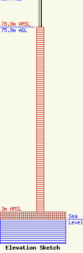
Site Elevation: 3 meters (10 ft) |
| Height of Structure: 75.9 meters (249 feet) |
| Overall Height Above Ground: 89 meters (292 feet) |
| Overall Height Above Mean Sea Level: 92 meters (302 feet) |
| Owner Info | SKINNER BROADCASTING INC
6431 NW 65TH TER
POMPANO BEACH, FL 33067-1546
(954) 340-3110
RADIOTV@CRIS.COM |
