|
|
Antenna Structure Registration 1030193 |
 |
Registration Info | Registration Number: 1030193 |
| File Number: A1313168 |
| FAA Study: 2025-AGL-5135-OE |
| FAA Issue Date: 04/17/2025 |
| Status: Constructed |
| Date Constructed: 05/15/1963 |
| NEPA: N |
Structure Info
| Structure Type: LTOWER |
| Structure Coordinates: 39-43-32.0 N 86-11-8.0 W (NAD 83) |
| Structure Coordinates: 39-43-31.8 N 86-11-08.0 W (Converted to NAD 27) |
| Structure Address: East Side Of S. Harding Street At White River |
| Structure City: Indianapolis, IN |
| Structure County: Marion County |
| Painting & Lighting Info |
FAA Circular #: 70/7460-1M |
FAA Chapters: 3, 4, 5, 15 |
| Elevation Info |
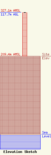
Site Elevation: 209.4 meters (687 ft) |
| Height of Structure: 116.7 meters (383 feet) |
| Overall Height Above Ground: 117.7 meters (386 feet) |
| Overall Height Above Mean Sea Level: 327.1 meters (1073 feet) |
| Owner Info | Continental Broadcast Group, LLC
180 Post Road East
Westport, CT 06880
(203) 293-8349
CharlesL@conncos.com |
| Contact Info | Continental Broadcast Group, LLC
180 Post Road East
Westport, CT 06880
(203) 293-8349
CharlesL@conncos.com |
