|
|
Antenna Structure Registration 1030598 |
 |
Registration Info | Registration Number: 1030598 |
| File Number: A1344493 |
| FAA Study: 2020-ASO-4212-OE |
| FAA Issue Date: 02/11/2020 |
| Status: Constructed |
| Date Constructed: 08/29/1993 |
| NEPA: N |
Structure Info
| Structure Type: LTOWER |
| Structure Coordinates: 34-27-48.5 N 86-38-34.4 W (NAD 83) |
| Structure Coordinates: 34-27-48.2 N 86-38-34.4 W (Converted to NAD 27) |
| Structure Address: 267 Fire Tower Road / Us-al-5008 |
| Structure City: Somerville, AL |
| Structure County: Morgan County |
| Painting & Lighting Info |
FAA Circular #: 70/7460-1L |
FAA Chapters: 4, 8, 12 |
| Elevation Info |
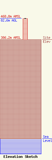
Site Elevation: 386.2 meters (1267 ft) |
| Height of Structure: 81.7 meters (268 feet) |
| Overall Height Above Ground: 82.6 meters (271 feet) |
| Overall Height Above Mean Sea Level: 468.8 meters (1538 feet) |
| Owner Info | Vertical Bridge CC FM, LLC
22 W Atlantic Avenue
Delray Beach, FL 33444
(561) 406-4015
fcc-faa@verticalbridge.com |
| Contact Info | Vertical Bridge CC FM, LLC
22 W Atlantic Avenue
Delray Beach, FL 33444
Richard Hickey
(561) 406-4015
fcc-faa@verticalbridge.com |
