|
|
Antenna Structure Registration 1030680 |
 |
Registration Info | Registration Number: 1030680 |
| File Number: A1304094 |
| FAA Study: 2011-ACE-1782-OE |
| FAA Issue Date: 07/27/2011 |
| Status: Constructed |
| Date Constructed: 01/01/1981 |
| FAA EMI: N |
| NEPA: N |
Structure Info
| Structure Type: TOWER |
| Structure Coordinates: 37-21-44.4 N 89-31-19.3 W (NAD 83) |
| Structure Coordinates: 37-21-44.2 N 89-31-19.0 W (Converted to NAD 27) |
| Structure Address: .7 Mi S Of Bainbridge Rd |
| Structure City: Cape Girardeau, MO |
| Structure County: Cape Girardeau County |
| Painting & Lighting Info |
FAA Circular #: 70/7460-1K |
FAA Chapters: 3, 4, 5, 12 |
Remarks: PRIOR STUDY 1981-ACE-674-OE |
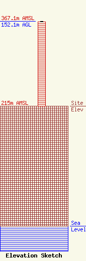
| Elevation Info |
Site Elevation: 215 meters (705 ft) |
| Height of Structure: 151.2 meters (496 feet) |
| Overall Height Above Ground: 152.1 meters (499 feet) |
| Overall Height Above Mean Sea Level: 367.1 meters (1204 feet) |
| Owner Info | GTC Uno, LLC
865
Rancho Cordova, CA 95741
(844) 482-8977
lkirth@gtctowers.com |
| Contact Info | GTC Uno, LLC
865
Rancho Cordova, CA 95741
Lucy Kirth
(844) 482-8977
lkirth@gtctowers.com |
