|
|
Antenna Structure Registration 1030758 |
 |
Registration Info | Registration Number: 1030758 |
| File Number: A1381175 |
| FAA Study: 2024-AGL-1762-OE |
| FAA Issue Date: 03/11/2024 |
| Status: Constructed |
| Date Constructed: 10/03/2024 |
| NEPA: N |
Structure Info
| Structure Type: LTOWER |
| Structure Coordinates: 39-46-53.4 N 86-9-29.1 W (NAD 83) |
| Structure Coordinates: 39-46-53.2 N 86-09-29.1 W (Converted to NAD 27) |
| Structure Address: Ctr Of Blk Formed By W 10th, W 11th, N Illinois & N Meridian Sts |
| Structure City: Indianapolis, IN |
| Structure County: Marion County |
| Painting & Lighting Info |
FAA Circular #: 70/7460-1M |
FAA Chapters: 4, 8, 15 |
Remarks: PRIOR STUDY 1981-AGL-28-OE |
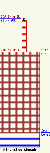
| Elevation Info |
Site Elevation: 218.5 meters (717 ft) |
| Height of Structure: 86 meters (282 feet) |
| Overall Height Above Ground: 91.4 meters (300 feet) |
| Overall Height Above Mean Sea Level: 309.9 meters (1017 feet) |
| Owner Info | VideoIndiana, Inc.
8401 Greensboro Drive
McLean, VA 22102
(703) 873-6600
lawdept@tegna.com |
| Contact Info | TEGNA Inc.
8401 Greensboro Drive
McLean, VA 22102
Denise Branson
(703) 873-6606
dbranson@tegna.com |
